This collection is no longer being updated. See IMERG monthly
This dataset algorithmically merges microwave data from multiple satellites, including SSMI, SSMIS, MHS, AMSU-B and AMSR-E, each inter-calibrated to the TRMM Combined Instrument.
Algorithm 3B43 is executed once per calendar month to produce the single, best-estimate precipitation rate and RMS precipitation-error estimate field (3B43) by combining the 3-hourly merged high-quality/IR estimates (3B42) with the monthly accumulated Global Precipitation Climatology Centre (GPCC) rain gauge analysis.
All of the global precipitation datasets have some calibrating data source, which is necessary to control bias differences between contributing satellites. The multi-satellite data are averaged to the monthly scale and combined with the Global Precipitation Climatology Centre's (GPCC) monthly surface precipitation gauge analysis. In each case the multi-satellite data are adjusted to the large-area mean of the gauge analysis, where available (mostly over land), and then combined with the gauge analysis using a simple inverse estimated-random-error variance weighting. Regions with poor gauge coverage, like central Africa and the oceans, have a higher weighting on the satellite input.
See the algorithm description and the file specification for details.
该文集已不再更新。见IMERG月刊
该数据集通过算法合并来自多颗卫星的微波数据,包括SSMI、SSMIS、MHS、AMSU-B和AMSR-E,每颗卫星都与TRMM组合仪器进行了相互校准。
算法3B43在每个日历月执行一次,通过将3小时合并的高质量/红外估计值(3B42)与每月累积的全球降水气候学中心(GPCC)雨量计分析相结合,产生单一的、最佳估计降水率和降水误差估计场(3B43)。
所有的全球降水数据集都有一些校准数据源,这对于控制贡献卫星之间的偏差差异是必要的。多卫星数据被平均到月度尺度,并与全球降水气候学中心(GPCC)的月度地面降水仪分析相结合。在每一种情况下,多卫星数据都被调整为水尺分析的大面积平均值,如果有的话(主要是在陆地上),然后使用一个简单的反估计-随机误差方差加权法与水尺分析相结合。仪表覆盖率低的地区,如非洲中部和海洋,对卫星输入的权重更高。
详见算法描述和文件说明。
Dataset Availability
1998-01-01T00:00:00 - 2019-12-01T00:00:00
Dataset Provider
NASA GES DISC at NASA Goddard Space Flight Center
Collection Snippet
ee.ImageCollection("TRMM/3B43V7")
Resolution
27830 meters
Bands Table
Name | Description | Min* | Max* | Units |
precipitation | Merged microwave/IR precipitation estimate | 0 | 6.73 | mm/hr |
relativeError | Merged microwave/IR precipitation random error estimate | 0.001 | 16.36 | mm/hr |
gaugeRelativeWeighting | Relative weighting of the rain gauges used in calibration | 0 | 100 | % |
* = Values are estimated
使用说明:
This dataset is in the public domain and is available without restriction on use and distribution. See NASA's Earth Science Data & Information Policy for additional information.
引用:
Adler, R.F., G.J. Huffman, A. Chang, R. Ferraro, P. Xie, J. Janowiak, B. Rudolf, U. Schneider, S. Curtis, D. Bolvin, A. Gruber, J. Susskind, P. Arkin, E.J. Nelkin, 2003: The Version 2 Global Precipitation Climatology Project (GPCP) Monthly Precipitation Analysis (1979-Present). J. Hydrometeor., 4(6), 1147-1167.
Huffman, G.J., 1997: Estimates of Root-Mean-Square Random Error for Finite Samples of Estimated Precipitation, J. Appl. Meteor., 1191-1201.
Huffman, G.J., 2012: Algorithm Theoretical Basis Document (ATBD) Version 3.0 for the NASA Global Precipitation Measurement (GPM) Integrated Multi-satellitE Retrievals for GPM (I-MERG). GPM Project, Greenbelt, MD, 29 pp.
Huffman, G.J., R.F. Adler, P. Arkin, A. Chang, R. Ferraro, A. Gruber, J. Janowiak, A. McNab, B. Rudolph, and U. Schneider, 1997: The Global Precipitation Climatology Project (GPCP) Combined Precipitation Dataset, Bul. Amer. Meteor. Soc., 78, 5-20.
Huffman, G.J., R.F. Adler, D.T. Bolvin, G. Gu, E.J. Nelkin, K.P. Bowman, Y. Hong, E.F. Stocker, D.B. Wolff, 2007: The TRMM Multi-satellite Precipitation Analysis: Quasi-Global, Multi-Year, Combined-Sensor Precipitation Estimates at Fine Scale. J. Hydrometeor., 8(1), 38-55.
Huffman, G.J., R.F. Adler, M. Morrissey, D.T. Bolvin, S. Curtis, R. Joyce, B McGavock, J. Susskind, 2001: Global Precipitation at One-Degree Daily Resolution from Multi-Satellite Observations. J. Hydrometeor., 2(1), 36-50.
Huffman, G.J., R.F. Adler, B. Rudolph, U. Schneider, and P. Keehn, 1995: Global Precipitation Estimates Based on a Technique for Combining Satellite-Based Estimates, Rain Gauge Analysis, and NWP Model Precipitation Information, J. Clim., 8, 1284-1295
代码:
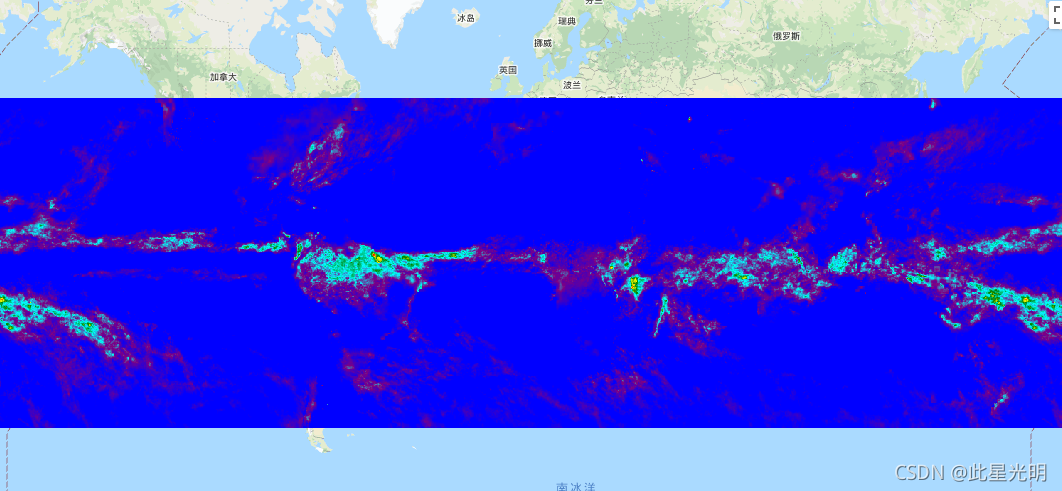
var dataset = ee.ImageCollection('TRMM/3B43V7')
                  .filter(ee.Filter.date('2018-04-01', '2018-05-01'));
var precipitation = dataset.select('precipitation');
var precipitationVis = {
  min: 0.1,
  max: 1.2,
  palette: ['blue', 'purple', 'cyan', 'green', 'yellow', 'red'],
};
Map.setCenter(6.746, 46.529, 3);
Map.addLayer(precipitation, precipitationVis, 'Precipitation');