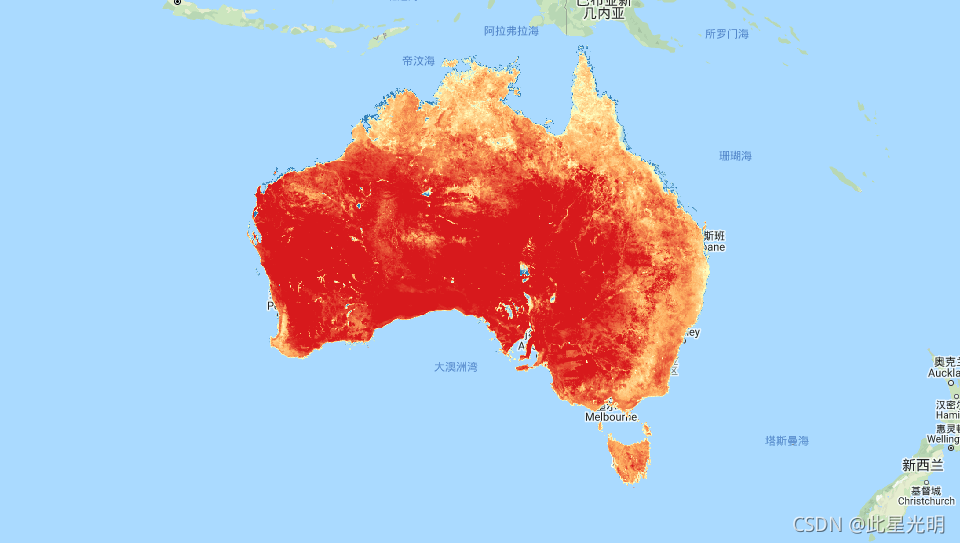
This dataset provides accurate actual evapotranspiration (AET or ETa) for Australia using the CMRSET algorithm. The AET band (named 'ETa') contains the average daily value from the CMRSET model for all cloud-free Landsat observations in that month (indicated with value 3 in the AET Data Source QA bits). After the Landsat 7 ETM+ Scan Line Corrector (SLC) failed on 31 May 2003, Landsat 7 ETM+ data are only used if there are no cloud-free Landsat 5 TM or Landsat 8 OLI data for that month. If there is no cloud-free Landsat available, then pixels are infilled with Landsat-VIIRS blended output (indicated with value 2 in the AET Data Source QA bits). If there is no VIIRS available in a month, then missing monthly AET values are linearly interpolated (indicated with value 1 in the AET Data Source QA bits). This means monthly 30 m AET data covering all Australia, with no gaps due to cloud, are available and ready to use.
Accurate AET information is important for irrigation, food security, and environmental management. Like many other parts of the world, water availability in Australia is limited and AET is the largest consumptive component of the water balance. In Australia 70% of available water is used for crop and pasture irrigation. Better monitoring will support improved water use efficiency in this sector, with any water savings available as environmental flows. Additionally, ground-water dependent ecosystems (GDE) occupy a small area yet are "biodiversity hotspots". Knowing their water needs enables enhanced management of these critical areas. AET can also be used to model the catchment water balance. If used in water balance (mass balance) calculations, then this AET value needs to be multiplied by the number of days in the month.
To let the developers know you are using this dataset, to get information on updates, or if you have any questions please contact: tim.mcvicar@csiro.au, tom.vanniel@csiro.au, jamie.vleeshouwer@csiro.au .
该数据集使用CMRSET算法为澳大利亚提供准确的实际蒸散量(AET或ETa)。AET波段(命名为 "ETa")包含CMRSET模型对该月所有无云Landsat观测的日均值(在AET数据源QA位中以3值表示)。在2003年5月31日Landsat 7 ETM+扫描线校正器(SLC)失效后,只有在该月没有无云的Landsat 5 TM或Landsat 8 OLI数据时,才会使用Landsat 7 ETM+数据。如果没有可用的无云Landsat,则用Landsat-VIIRS的混合输出来填充像素(在AET数据源QA位中用数值2表示)。如果某月没有VIIRS,那么缺失的月度AET值将被线性内插(在AET数据源QA位中以数值1表示)。这意味着覆盖整个澳大利亚的月度30米AET数据,没有因云层而出现的空白,是可以使用的。
准确的AET信息对灌溉、食品安全和环境管理非常重要。与世界上许多其他地区一样,澳大利亚的水供应是有限的,AET是水平衡中最大的消耗性部分。在澳大利亚,70%的可用水被用于作物和牧场的灌溉。更好的监测将有助于提高该部门的用水效率,任何节水都可以作为环境流量。此外,依赖地下水的生态系统(GDE)所占面积很小,但却是 "生物多样性热点"。了解它们的用水需求,可以加强对这些关键区域的管理。AET也可以用来模拟集水区的水平衡。如果用于水平衡(质量平衡)计算,那么这个AET值需要乘以该月的天数。
要让开发者知道你在使用这个数据集,要获得更新信息,或有任何问题,请联系:tim.mcvicar@csiro.au, tom.vanniel@csiro.au, jamie.vleeshouwer@csiro.au 。
Dataset Availability
2012-02-01T00:00:00 - 2021-02-01T00:00:00
Dataset Provider
TERN Landscapes / CSIRO Land and Water
Collection Snippet
ee.ImageCollection("TERN/AET/CMRSET_LANDSAT_V2_1")
Resolution
30 meters
Bands Table
Name | Description | Units |
ETa | Average daily evapotranspiration | mm/day |
pixel_qa | Pixel QA attributes | |
pixel_qa Bitmask |
| |
数据引用:
Guerschman, J.P., McVicar, T.R., Vleeshouwer, Van Niel, T.G., Peña-Arancibia, J.L., and Chen, Y. (2021) Estimating actual evapotranspiration continentally at field-to-landscape scales by calibrating the CMRSET algorithm with MODIS, VIIRS, Landsat and Sentinel-2 reflective data. Journal of Hydrology (In Preparation)
代码:
var dataset = ee.ImageCollection("TERN/AET/CMRSET_LANDSAT_V2_1");

var visualization = {
  bands: ['ETa'],
  min: 1.0,
  max: 7.0,
  palette: ["d7191c","fdae61","ffffbf","abd9e9","2c7bb6"]
};

Map.setCenter(132.0, -27.0, 4);

Map.addLayer(dataset, visualization, "Average daily evaportranspiration");